Click here to open the sub-menu!

English text deutsche Fassung

Exploring methods of three-dimensional documentation (3)


Recording spatial qualities 
by means of triangle networks

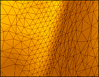
A more advanced method of 3D reconstruction is to define a virtual model as a set of points in space (x,y,z coordinates) buildin a point cloud; when these points are connected with each other, the surface is defined by a large set of triangles (mesh file).

Such 3D files represent the surface of the object. Simple models can be freely constructed, using special software, like 3D StudioMax. To create a model of a complex object, the object´s geometry has to be captured by a 3D recording device.

There are several methods to determine an objects´s topographic characteristics:

Mechanical methods, like following the surface of the object with a dull needle, attached to a CNC-machine or another mechanical measuring device.

Photogrammetry, based on a series of photos that define the outline of the object.

Laser triangulation, calculating the z-distance (depth) of a point matrix from the
reflection of a laser beam, projected by a rotating mirror.

Phase shift, measuring distances from the phase shift of a projected light beam.

Structured light: stripe patterns are projected on the object, and recorded by a
digital camera.

Time-of-flight: calculating the distance between lens and object from the
time a projected light beam needs to return (for large objects and landscapes).


With most methods, several shots are taken from different angles, or the object is placed on a turntable. In the end, the different scans or "patches" have to be registered and merged into a single model.


© Copyright 2002 for data collection and research by Hans de Roos.
© Copyright 2002 for Website design by Borbála de Roos.
Browser or display problems?

Last update of this page: 15.08.2002